Pioneer Trail
Mabukuwene Nature Reserve Fridays 19:00 - 21:00 hrs | Norman Scott Norman's Email address |
With thanks to:- Editor, typist, distributor - Leon Wuyts
In January the Troop bade farewell to Patrol Leader Paul Carlson. Paul obtained very good
grades in his 'A' level examinations and has set his sights on going to Australia, later in the year,
to attend university. All the best for your future, Paul.
Patrol Leader Leon Wuyts, gained good grades in his 'O' level examinations and is now in the
Lower Sixth form at Christian Brothers College. Well done, Leon.
Our former editor of Pioneer Trail, Mrs Karen FitzPatrick, published her last magazine in
September 2005. My thanks to you Karen for your support of our Troop through the production of
our magazine which, being on the Matabeleland Scouting web page, has a worldwide circulation.
Taking over the task of keeping our readers abreast of our Troop's adventurous activities, is
Patrol Leader Leon Wuyts. Yes, Pioneer Trail is now completely produced by the young men of
our Troop, from writing the articles, typing and through to despatch. The production of the
magazine is no mean task, for it involves the adding and typing of the articles, the downloading
and insertion of photographs and then e-mailing it to some eighty odd individual addresses. Mr
Hylton Garriock, to whom we are very grateful, posts it on our web page. All the best, Leon, and
thank you for your interest, especially as you are studying for your 'A' levels, which of necessity
must be your priority.
The reports by the Scouts of our Troop activities give a good idea of the varied nature of the
programme offered. However, offering activities is one thing, for they need to be supported in
order that Scouting comes alive. Scouting in our Troop is alive because of parental support and
for this I would like to record my sincere Thanks to you, the parents. Of equal importance, is the
support we receive from people who are not directly connected with the Troop but never-the-less
support us financially or materially or through the giving of their time, experience and advice.
Some of our supporters live in other countries and, reading about our activities through this
magazine, actively support us. I am aware that those people do not want publicity, for they are,
through their genuine generosity helping us to achieve, to broaden our horizons and encouraging
us to be considerate and dependable citizens. To our supporters, you can be sure that the
support you give, in whatever form, gets passed on to the young men of the 1st. They are really
great chaps, and I Thank You for what you are doing for us.
Click to enlarge: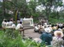 Father Odilo giving the Baden-Powell Day Service on the 19th of February. |
Our monthly hikes continue to achieve
their goal of teaching each of us to
become self-dependant, yet at the same
time dependant on each other, to see
more of our country, to appreciate the
beauty of the bushveld, the granite hills
of the Matopos and most importantly to
mentally relax and have fun. We have
already undertaken our main hike of the
year, which is our Chimanimani
mountain hike and expedition. This was
made possible through a number of
generous donations, the main one being
from a Scouting friend in England. Neil,
who is actively involved in Air Scouting
in England, has visited Zimbabwe,
reads our magazine, and offered his
help in whatever way I saw fit. Well the
Chimanimani hike/expedition of six days
duration was top priority. Why? Our Scouts saw places in Zimbabwe they never thought existed
and met really friendly, helpful rural people. A letter from one of them appears in this edition. Our
Scouts hiked in the mountains along Zimbabwe's eastern border, soaring to 2440 metres (8000
feet) above sea level - Bulawayo's altitude is 1371 metres (4500 feet). They had the opportunity
of swimming in the crystal clear streams and lakes of the mountains and lived together
harmoniously for six days - quite an achievement.
Our Parent's Camp held on the 11th and 12th of February was not well supported, but enjoyed by
those who, despite the threatening rain clouds, spent a weekend under canvas in our campsite at
Gordon Park. Fortunately, the rain held off. The activities of making camp, cooking over an open
fire, abseiling, participating in the evening campfire and attending the monthly Gordon Park
church service were all
experiences not to be missed.
Click to enlarge: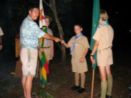 A Proud Father. Shaun being presented his badges by his father at the Investiture. |
During the campfire, Leon
Wuyts was promoted to Patrol
Leader of Eagle Patrol, and he
was also presented with his
Advanced Scout badge. Scouts
Dylan Sandwith and Chayce
Zangel were presented with
their Discoverer badges, and
the three Daly brothers, Peter,
Martin and Shaun were officially
invested into the Troop.
Welcome to the Troop guys,
and may you receive the best
you can from your Scouting
experiences. Mr Martin
Sanderson once again
enlivened our campfire with a
true yarn on the discovery of a
fossil of a dinosaur just north of
Bulawayo in the early 1950's.
As this type had never been discovered previously it was given the official name of Syntarsus
rhodesiensis. As part of his requirements for his Scout tests, Leon conducted the church service
in the form of a Scouts' Own in the Saint George's Chapel on the Sunday for over forty visitors
from Bulawayo who had come for the monthly service.
The usual Troop meeting for Friday the 24th of March was abandoned at shorts notice in favour of
the Scouts supporting the King George VI Rehabilitation Centre's Song and Dance show at the
Bulawayo Theatre. The show was well worth attending and I would like to thank the eight
members of the Troop for turning up in uniform. You were noticed and your smart turnout
commented upon.
On the Friday evening prior to the Troop leaving on their Chimanimani hike/expedition, a parcel
arrived from Canada. The Scouts gathered around as Leon opened the parcel and distributed its
contents of sweets, scarves, badges, craft knives and key rings to mention some of the items.
The Chadwick family, Tim and David having been members of the Troop before immigrating to
Canada last year, had sent the parcel. Thanks guys for your goodies and letters, we really
appreciated you thinking of us. Some of the sweets even reached the top of Peza in Chimanimani
before being guzzled. Their letters enclosed in the parcel are reproduced in this edition.
 And now, until the next time, it's back to my hammock beneath my favourite Pseudolachnostylis
Maprouneifolia with a floppy hat pulled over my eyes as I dream of all the challenging and
exciting activities our Scouts will be participating in.
And now, until the next time, it's back to my hammock beneath my favourite Pseudolachnostylis
Maprouneifolia with a floppy hat pulled over my eyes as I dream of all the challenging and
exciting activities our Scouts will be participating in.
N. Scott
Scout Leader

Gali Hike
6th - 7th January 2006
Click to enlarge: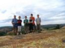 All set - a band of adventurers on the top of Gali, eager to be off. |
At Gordon Park we
loaded our packs into Mr Daly's
truck and went on our way. We
arrived at Gali at around eight
o'clock. We trundled up to the top
of the relatively large boulder that
is Gali and pitched camp. The
sheet lightning on the way to Gali
was amazing. Norm brought along
a bivvy and we slept under that,
but, as Murphy's Law dictates, the
clouds that had threatened to
burst thankfully did not.
In the morning we had our
breakfast, packed up our kit and
got going. We took a detour off
the planned route because there
was a dam just off the road that
Norm wanted to see. Leon
somehow walked almost the entire hike barefoot. I went barefoot for the last kilometre and my
feet were aching! We climbed up Shumba Shaba, as it lay directly on our path to Gordon Park,
and after a quick dip I managed to pass a few things for my next badge.
On the way down, I took an accidental detour that, by sheer dumb luck, brought me back onto the
planned route. When we got back to Gordon Park we had our lunch and then fooled around for a
while before we left for Bulawayo.
Kieran FitzPatrick
The 1st Pioneer Scout Group would like to express their most appreciative thanks to the following, who have continued, often behind the scenes without recognition, to support us in all our endeavours. We appreciate your concern and help, and thank you most sincerely.
Mr Hylton Garriock, our Webmaster, who gives unfailing support to the Troop,
Mr Ken Nortje, for visiting us on our Chim's hike, and taking the time to camp a night with us,
Father Odilo, for always lifting our spirits, and showing us the right from the wrong,
Mr Norman Scott, for looking after the Park for us, and for giving us the opportunities we desire,
Mr and Mrs Ross, for your unfailing enthusiasm in the affairs of our Troop,
Our parents, friends and benefactors, those close to our hearts, and always in our minds,
By giving us the opportunity, inspiration, commitment and support you do, our lives will forever be enriched. Though at times it may seem we are ungrateful, and you wonder, remember always the thoughts of kindness you sow in our minds, and the joy you spread in our hearts.
Matopos Conservation Society Field Trip
Sunday 22nd January 2006
Before this, Norm had been very specific as to the exact time of departure, exactly 8, and so, as always happens when a schedule is being kept to, a couple of the Scouts were left behind, so it was only Norm, Chris, Chayce and me on this trip. If the others had known what was in store for them, they might have made a better effort to get to the garage on time.
Click to enlarge: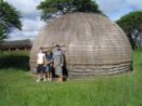 Outside one of the beehive huts at Old Bulawayo - Leon, Chayce and Chris. |
So, off the four of us trundled along
a very unfamiliar road, the Criterion
road, heading out to a not-sofamiliar
section of our beloved
Matopos. After quite a bumpy ride,
we finally arrived at Old Bulawayo,
which was being turned into a
tourist-centred attraction park. We
had a brief view of the huts, with
Norm breathing down our backs, as
it looked like we would be late. So,
after a quick stop, we were bundled
off again, destination: Cave of the
Stork.
And so we continued, finally
reaching the site of Rhodes' first
Indaba during the Matabele
Rebellion of 1896, where an
unarmed Rhodes gathered together
the chiefs of the surrounding areas,
and with great courage, negotiated peace and an end to the Rebellion. Here we met up with the
Society, who were receiving a quick talk on the Rebellion and the Indaba. Unfortunately we
arrived at the end of the talk, and so we had to carry on, following a train of cars through a
beautiful wooded area, where Baden-Powell himself had fought 100 years ago.
We finally reached a vlei, where we all stopped and found places to set up braiis for lunch, a very
important exercise, requiring much room, and a perfect view, and so accordingly, Norm engaged
four-wheel drive, and headed up the small hill we had parked upon, to the great glee of us three
youngsters. We had lunch in a small nook between the rocks, and soon after headed out on the
"short walk" to the cave.
This "short walk", though highly enjoyable, stretched out, becoming somewhat longer than one of
our hikes, and we were beginning to get anxious. The return expedition was growing longer, and
several grey-haired people were beginning to show signs of fatigue. "Not long to go," kept
resonating down the long, sweaty line of people, repeated each time with just a little lack of
enthusiasm, and a small increase in sarcasm with each cry.
We eventually reached a large gomo (mountain), and were told, "come on, it's just up there."
They never mentioned that we would be required to bring our own air-masks! but being
adventurous, we began to climb up this huge mountain, which was as steep as anything! Our
thoughts kept returning to our descent, and the speeds involved if we were to inattentively slip.
Despite this, or perhaps because of this, we all reached the top of the mountain, rather
breathless, but as we turned and looked around us, the view was incredible, and the huffing and
puffing seemed well worth it. Far in the distance, we could see the upper reaches of the Mchabezi
Dam, whilst the cave afforded us with great debate, on why it was known as "Cave of the Storks",
whilst the paintings really looked like kangaroos!
However, we could not stay long up on the mountain, as we had to get going. So we began the
long tortuous way back to the cars, with pit stops along the way to wait for the slow but steady
ones. It was however a very enjoyable walk back, and as we were coming up to the cars, coming
up the last stretch of vlei, the rain swept slowly down the valley towards us, a gentle curtain of
softly falling water. There's little else that Scouts hate most than getting wet, so the mad scramble
to the car is excusable.
Click to enlarge: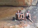 Enjoying the view - Norm, Leon and Chayce relax in the Cave of the Storks. |
However, the rain didn't last
long, only a sprinkle really,
and after a short breather, we
all gathered at the bottom of
the dwala we were perched
precariously upon for a talk by
Mrs FitzPatrick, concerning
scorpions, spiders and other
things that make normal,
respectable people's skin
crawl. Us Scouts were
amazed, and it was perhaps
the first time we had paid
proper attention to a long,
monotonous "talk"! All the
information she provided us
was very interesting, along
with several specimens she
had brought, and we hope,
with her permission, to
reproduce some of here
articles in future magazines.
And so, after the talk, the official outing was over, and everyone got ready to head home. And so
it was that four grubby Scouts climbed into the back of Nguluvane and headed off along the road
back to civilization. However, in no way can you trust a Scout's sense of direction (no matter what
the text-books say). And so, where the road forks, and all the other tracks lead one way, we find
one set of tracks going the other way, into the blue distant yonder!
In the far, far distance we could see the hill that was How Mine, in the general direction of town,
and using this as our lighthouse, we set off. We followed the road, which was dirt with many
bumps and humps for quite some time, giving a lift to a couple of gold-panners heading for the
school. We found out that they operated in the area, and sold their gold to the mine, which was
forced to buy from them, whatever the grade.
Anyway, we finally reached a growth point, which I have forgotten the name to, and asked some
rather drunk looking revellers which way to How Mine. Of course, they pointed in the direction we
had just come, telling us that a few metres down the road was another road which went to the
mine. Ah ha! Success, or so we thought.
We backtracked, crawling along, looking for this 'road', which we found at last. To our surprise,
the 'road' disintegrated into 'track' and finally into 'washed-out path.' Well, why else buy a Land
Rover? Four-wheel drive engaged, off we headed, wisely ignoring the paths that branched off to
either side of us.
However, all was not as difficult as it might seem. You see, we had one unfailing principle in the
back of our minds, which we followed faithfully and unquestionably: bicycle tracks. From the
growth point, we had followed a set of bicycle tracks all along the path, and when we felt a bit
confused (never lost however..) we had only to yell, "there - bicycle tracks!" and we would roar
off after them. What would have happened if we had met the bicycle, I do not know, but thankfully
we never did.
And so, by stages, we worked our way to How Mine. We were very lucky in several instances, the
main one being the fact that we very nearly drove up and over a small dam wall, which the path,
oblivious, just followed. Luckily, we got out to see what was on the other side of this very steep
bank, as we would have had some fun trying to get out of the dam if we had driven over the wall!
Nonetheless, we did finally reach the mine, arriving at the back-entrance, where we had a quick
look at the huge pools, which they use in their processing. However, we were not allowed to drive
through the mine, for some strange reason, and so had to follow the maintenance track around it.
Nevertheless, we finally made it back to the road, and set our sights on Bulawayo.
This was, I must admit, one of the most exciting trips I've been on with Norm, and I'm glad now
that the opportunity was taken, and the experience gained.
And if you ever get temporarily confused, just look for bicycle tracks..
Leon Wuyts
Patrol Leader
Mbalebale Hike
3rd - 4th March 2006
It took us about half an hour to get to the gate of Matopos National Park. When we got to Gordon Park it was to find Mr and Mrs Ross already there, and they agreed to take us to where we were going to camp for the night. When we got there, we took all our kit out of the trailer and laid out our sleeping bags; me, Chayce and my brother slept next to each other. It was getting late so we ate dinner and went to bed.
We woke up early and climbed a smallish kopje to look for game, but didn't see any. We then went back down to have some breakfast, and pack our kit, and started our hike back to Gordon Park.
We walked along a dirt road for a bit until we turned off into the vlei, walking for quite a way, until we came across some fresh rhino tracks. So we took off our packs, had a drink and looked around. Little did we know that we were right next to a cave that we were supposed to look at, but Norm had forgotten that it was right behind us.. So he said it must be somewhere over there, and off we went, walking for about 15 minutes until I saw a very weird looking rock that Norm said looked very familiar to him. So we put down our packs and Norm went off with Leon and the map to go look again. He came back and said we had been sitting right next to the cave!
Click to enlarge: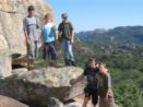 At the top of the world - Leon, Martin, Scott, Chayce and Peter at the top of Mbalebale Cave. |
When we got to the cave,
Norm showed us the cave
paintings, some of the
best in the Matopos, and
also a rock that was
suspended so that it
looked like it was going to
fall at any minute! Then
we carried on with our
hike through the vlei, until
we got to the main road,
we then walked along the
road until we reached
White Rhino Shelter,
where we looked at the
paintings and played
around for a while.
We finally got back on our
feet and walked down
another way into Gordon
Park and followed the
roads through the Park
down to Headquarters,
where the landy was parked, then we put all our kit into the trailer and went and had some much
needed lunch. We then spent the afternoon helping Norm with some small things, and by the time
we were finished it was already 5 o'clock, time to go back home after a long day's walk, as by this
time most of us were exhausted.
Peter Daly
BP Camp -- BP Day Service
18th - 19th February
Chief Scout's MessageMy greetings to you all, young and old Scouts.
I wish to take this opportunity, as we celebrate the birthday of our Founder, Lord Robert Baden- Powell, to thank all our Scout Leaders from the Patrol to National level on their daily commitment to Scouting work and education. I have no sufficient words to express my gratitude other than to offer my prayers to God and ask Him to reward them abundantly in His own way.
I want to thank the parents who allow you to become members of this great movement. We recognize and appreciate their interest, presence and support they continue to give to Scouting.
I want to thank our young people, the owners of the movement, for your participation in the many projects you are involved in for your personal growth and development.
I shall this year address you on the topical issue of the HIV and AIDS pandemic.
We commemorate this day to our Founder, as we equally celebrate the birthday of our State President, His Excellency Comrade Robert Mugabe, whose birthday falls on the 21st of February. The State President is the Patron of our movement in Zimbabwe.
We applaud the President's continued interest in the affairs of young people. We are appealing to him to provide land and resources to develop youth centres and facilities for educational, cultural and social activities of young people for their various associations. We are appealing to him to actively provide linkages with the rest of the youth of the world by facilitating attendance of delegates to seminars, conferences, jamborees and workshops that are held from time to time.
As we celebrate, we need to reaffirm our Scout Promise and Law. We need to rededicate ourselves to service towards our country and our people. We need to spend time with nature. We need to meditate and keep our body and soul healthy. We need to recognize the existence of the Almighty, our Creator and Saviour. We need to obey the Scout Law.
The scourge of HIV and AIDS haunts the nation. The virus is real and it kills. It kills young people and old people. As Scout Leaders, we will be failing in our duty if we do not talk about the dangers of this virus. I urge all Leaders to acquire sufficient knowledge about this disease so that we can confidently impart the correct information to our young people who are in the vulnerable group. We need to fight ignorance and poverty if we are to make an impact in society. As Scouts we are already playing our part in informing our peers. We are running a project in partnership with the National AIDS Council.
To all our young people, I say:
· There is no cure for this disease
· Abstain from having sex until you are married
· Stick to one partner
· Avoid contact with infected blood
· Refrain from taking dangerous and prohibited drugs
As Scouts, we are being urged to learn more about this disease and we are being asked to live to the high standards and values we have set for ourselves. By saying "No to Sex" we can protect ourselves from dangers and diseases.
If you get sexually abused or raped, you must immediately tell and adult you trust and report the matter to the police without any delay.
To those who are already affected and infected, Scouts are required to offer help and comfort. We are required to be friendly and to encourage others to be friendly to them.
As we celebrate this day, let us prepare ourselves for the Centenary Celebrations of our Movement, to be held in 2007. Let us see many groups from Zimbabwe converge at Brown Sea Island in England and meet other youths from across the world, from different cultural and social backgrounds.
In conclusion, I ask you all to remain good Scouts, and to encourage others to become Scouts.
Chris Mbanga
Chief Scout of Zimbabwe
March Hike: A hike in history
3rd - 4th March 2006
On a gloomy, drizzly sort of Friday, once again Christ the King Church was invaded by us eager quivering balls of excitement: hike weekend. However, the forecast was not good, rain threatened, and as Scouts dissolve in water, only three of us had the courage, or lack of intelligence, to turn up: Norm, Martin and me. This was going to be an interesting hike however, as we would be visiting two places of great interest, one human, the other natural.
And so, off we set, buttoned up against the cold, along the well-worn road to the Matopos National Park. The initial plan for this hike was to be from Three-Sisters to Gordon Park, crossing iMadzi, joining the road, and a pleasant walk into the park. But, unfortunately, the place in which we were to camp the night was buried under a heavy layer of mud! Thick red, clay-like mud! So that plan was abandoned, and off we trundled to a different side of the park, still unknown territory to us new recruits.
We carried on past our usual turnoff to the National Park, and all my thoughts of hot coffee flew out the window with it. But not far along this road we turned off, following a dirt track into what seemed to be a wide clearing in the bush, with what looked like a dip and a dilapidated shed poking their heads out of the waist-high grass. Where were we?
Click to enlarge: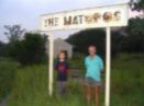 Norm and Martin standing underneath the old Terminus sign. |
Norm stopped the landy and we all piled out,
wondering where we were, and why we were
here and not drinking hot coffee in a warm
sleeping bag. However, we began to piece
together where we were, following a railway
line - in the middle of the bush if you don't
mind - towards the shed, which we now
noticed had a sign in front of it, with the words,
The Matopos, written upon it. Well, yes, we
knew it was the Matopos.. slowly the gears
began to move - it was very cold - and our
brains began to piece together the evidence
before us.
This, it appeared was the famous "Railway
built for Pleasure," foreseen by Rhodes, and
set out in his Will: "to make a short railway line
.. so that the people of Bulawayo may enjoy
the glory of the Matopos from Saturday to Monday." The spark was lighted, and we set off
through the long grass, dripping with water, off into the hazy mists of the past, back into the times
of 1903.
On the 7th of November 1903, the first train arrived at the Matopos Branch, as the line was called,
followed two days later by a special excursion train, to celebrate the birthday of King Edward VII.
Rhodes' dream had been fulfilled, and the people of Bulawayo could readily and easily visit the
same places of beauty and pleasure that we, as Scouts, sometimes take for granted.
It is believed that Alfred Beit and Dr. Jameson planned the construction of the line during their
visit to Rhodesia in 1902, but apparently no official contract was drawn up. However, as influence
mounted, a railway construction company named Pauling & Company, who was building the line
from Bulawayo to Wankie in 1902-1903, were heavily involved in the construction of the new line.
Mr. S. F. Townsend was placed in supervision of the construction at the request and expense of
the Rhode's Trustees. The total cost of the nine-mile line which branched off from the main south
line at Westacre Junction, sixteen miles from Bulawayo, was about 11 000 pounds.
It is interesting to note, however, that the nine miles of standard 3' 6" gauge line from Westacre
Junction was built with 40 lb. Rails, which had been uplifted from the original Vryburg-Bulawayo
construction.
At the time of the opening of the line there was already a hotel at the Terminus, which advertised
that a "wagonette and mules will always be in attendance for the convenience of visitors wishing
to proceed to World's View at a moderate charge."
The original hotel was a wood-and-corrugated-iron building, and the 'Bulawayo Chronicle', of the
11th of November remarked that "the hotel, which is not a very imposing appearance, is
pleasantly situated on the outskirts of the Matopos," adding that the view from the hotel was of
itself "almost enough to satisfy one on a first visit. The catering at the hotel" continued the
reporter "is of an excellent nature, and the building itself had been comfortably furnished, smoking
and billiard rooms being provided for the use of the sterner sex."
Click to enlarge: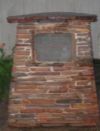 "Matopos Branch Line This plaque marks the site of the Railway Terminus of the Matopos Branch Line. Opened 7th November 1903. Closed 2nd June 1948." |
However, by the time we arrived on the scene, the
hotel was lost to history, and now only memory visits
it. We walked along the side of the track, following the
station into the shed, all the while feeling the touch of
the people who had known it in it's heyday, when the
sound of laughter floated in the air, of the jokes and
memories that were made were we stood.
Now, little remains. A plaque rests in front of the shed,
telling of the history of the Matopos Branch, but the
train no longer runs, and few people come to visit the
once blooming station.
Tuesday, 1st June 1948, saw the last train run over the
Matopos Branch, seen off by Sir Arthur Griffin (the
General Manager of Rhodesia Railways) and a
number of other senior railway personnel. It was
hauled by one of the original engines (No. 72) built in
1900 at Glasgow for the Rhodesia Railway Company
Limited.
There was a delayed start from Bulawayo owing to the
late running of a main line train from the south, but
engine No. 72 tackled the job with some gusto despite
her age. She was burnished until she shone, and
decorated with flags, and succeeded in making up
time on her last run to Matopos where the train was
greeted by Mr. Fryer who had been Railway Agent at the terminus for the preceding twenty-four
years. He is justifiably proud of the fact that not a single claim arose in respect to his handling of a
great variety of traffic in all those years. Railwaymen are equally glad that, so far as can be
ascertained, the Matopos train remained accident free throughout its forty-five years of operation.
On its final stop at the Terminus those who had gathered, a little saddened by the occasion,
drank a valedictory toast, appropriately in beer. Detonators had been placed on the line, so
engine No. 72 made her final exit from Matopos to the accompaniment of loud bangs.
Various factors led to the decision to close this historic Branch. There was an extensive roadbuilding
programme initiated during the trade depression of 1931-1932 which, combined with an
ever increasing number of private motor cars, caused a marked decline in the use of the Matopos
passenger services, while at the same time the rapid development of the Railway's own Road
Motor Services, with their greater flexibility to and from the Antelope Mine direction, eliminated
much of the goods traffic previously carried by rail to Matopos for onward transmission - by oxwagon
in the earlier days. Then again, by 1948 all of the old locomotives used on this Branch line
were nearing the end of their useful life, and to have used larger ones would have involved
extensive expenditure in strengthening the track.
It has often been said that the history of the early years of the Railways in Rhodesia is to a large
extent the history of the country itself, and in recalling the old Matopos railway with its happy
memories of relaxful days we may well reflect that it had a touch of time about it.
Amid the memories of the terminus we did not stay long. The clouds threatened overhead, and
time drew on, as it always does. And so, we turned, and left the history behind us, continuing on
our hike. But strangely, that whole hike seemed drenched in the past.
We camped the night at a picnic site, close to the Old Gates, in a rondavel that, had we looked
above us, we would have noticed had a huge hole in the roof. Of course, halfway through the
night, the clouds broke and the rain came crashing down, causing us a night of considerable
anguish. But what is the fun of hiking, without the pain?
The next morning we woke to a world clean and fresh, which we set off to explore after a hot
breakfast. We followed a stream, which had grown up in the night, along a very overgrown vlei,
until we came to a wall of thick trees. We could hear a river flowing within the trees, and as we
came up to it, we suddenly realized: it was the Maleme, in full flood. Some trees were a metre
underwater, and it was at least two metres into either side of the bank.
Oh, well. That's that. We were supposed to cross the Maleme, our destination was just on the
other side. So we had to turn around and go back, in order to cross the Maleme at a bridge higher
up the road. However, we took the wrong way back, and ended up paying a quick stop to a lodge
close by, Ingwe Lodge I think it was, before continuing on to the car. We piled in and drove off, to
cross the Maleme and visit the next destination on our hike: the Natural Wall.
Click to enlarge: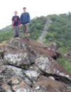 Leon and Martin atop the Natural Wall, which can be seen stretching away into the distance. |
We drove for quite a while, on the other side of the
Maleme, until suddenly Norm stopped the car, smiled
and said that we had passed the Natural Wall about ten
metres back, had any of us noticed? I must admit that
none of us had, so we jumped out and had a look, and
then we realized why we should never have missed it.
Stretching up one either side of the road was a long
stretch of rock, greenish in colour, about two metres
wide, and four or five high. The road passed through a
gap in the wall, with it continuing up and over the two
kopjes on either side of it. The rock is a form of dolerite,
which is a greenish-black finely crystalline rock closely
related to basalt lava, though in this form it never
reached the surface.
The Natural Wall on which we stood, known as
Shentendebudzi, has been traced from the Antelope
Road almost due south through the hills for a distance of
at least twenty-seven miles. Its wall-like appearance is
due to the natural joints in the dolerite, which were
formed by shrinkage when the rock solidified form the
molten state in which it was injected. These joints are
lines of weakness, which have been picked out by the
weather.
The name Shentendebudzi is Chikaranga and seems to be associated with the idea of turning
away, or perhaps an obstacle, which must be gone round.
We stayed at the Natural Wall for some time, and took several pictures of it. After that, we
continued on, returning to where we left the trail, where Norm left Martin and me and drove on in
the landy, and we carried on our hike, following the road until we met up with him at a kopje quite
close to the Park, where, to round off our historical interlude, we climbed up and found some
grain bins, but no paintings. We didn't stay here long, but carried on to the Park, to our hot coffee.
It was quite a hike, all in all. A hike, under the black clouds of an African storm, which showed
me, more than anything else, the power of time. The Natural Wall has been in existence for
millions of years, indeed it took millions of years to form, and it is still there, and will be for many,
many years to come. No power man wields can do the same, for though a place of great
happiness, and the result of great vision, the Matopos Terminus cannot do the same.
And so, we learn and continue. We learn to set our faith not in the deeds of man, which pass
away. We learn also however, to respect those deeds, and remember them, for though they pass,
they show great courage of spirit.
But most of all, we learn the practicalities of life: we learn not to sleep under a broken roof, not to
try and cross a river in flood, to smile and continue through the cold and wet, and to appreciate a
well-earned cup of hot coffee.
Ah, hot coffee.
Leon Wuyts
Patrol Leader
KG6 Concert - Ingoma Lokugido
Friday 24th March 2006
On the evening of Friday March 24th 2006, the 1st Pioneer Scout Troop forwent their usual Friday evening gathering at Mabukuweni and instead turned out in force to support the King George VI annual fundraising concert at the local theatre. A very worthwhile cause and an evening which proved most memorable.
The rows of cars outside and the mass of people in the foyer showed that Bulawayo had turned out in force to support KGVI. The auditorium was packed - full house!
From the moment the show opened it was go, go, go all the way --- music, noise, fun, laughter. The audience was swept along in irresistible foot tapping, handclapping, sing along enjoyment.
Close your eyes and you would never have known that the performers were all physically handicapped in some way. We watched the young dancers who opened the show. Then we were told they were deaf. Deaf????? We were more than impressed.
I am actually loath to comment any further on the "disabled" side of it all because they sure took the "dis" out of the word. From the powerful, beautiful voice of Prudence Mabhena, so wonderfully supported by Marvelous Mbulo, Sanelisiwe Moyo and Tapiwa Nyengera, through the talented members of the band we could only marvel again and again.
For me the overriding impact was that these people had not bowed under the weight of their handicaps, they just bounced over the top of them, grabbed the talents God gave them and had a ball making the most of their ability, sharing it with us --- and loving every minute of it.
They shared their musical talents and their great sense of humour and fun with us and I think we came out by far the richer. BRAVO! I am so glad I went. And I'm sure that the boys gained immensely from the experience of seeing what one can do regardless of what obstacles may appear to be in the way. Next time I feel sorry for myself I shall remember how lifted up I felt by the heart warming show the KGVI "kids" gave us.
Mary Ann Wuyts
Parent
Chimanimani Expedition and Hike
23rd - 28th April 2006
It is Sunday afternoon, Peter, Martin, Dylan, Chayce and myself plus our heavy backpacks loaded with food for the next five days and not much else, arrived with our families (who where there to say bye and have a week of peace) at Leon's house to wait for Norman, who promptly arrived at 4.00pm. This was the start of our Chim's hike, we were all very excited as only two of us, Dylan and myself, had been on this hike before. Norm and Leon tried to organise the packing of the trailer and landy. After a few tries all our packs went in. Norm asked Leon's mother to read a bible verse about safe travelling. With the last byes to our parents and hoping that we had not forgotten anything, it was off on the road. Norm stopped to buy all of us a coke, and after buying them Chayce kept asking when we could have them. On the road we would not stop talking and eating the bits of food that we had brought with us,
It was much later when we stopped for the night. Norm found a river to stop by, some of us went down for a look then it was back to set up our beds for the night, not that we slept as the mozzie's were out. All too soon morning came and, breakfast done, we were off again for a long drive.
Click to enlarge: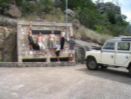 Manyuchi Dam - five grubby Scouts and a landrover - recipe for adventure.. |
After a while, we passed Zvishavane and
the asbestos factory, where Norm stopped
so that those who had brought cameras
could take photos and a quick talk form
Norm.
Our next stop was Manyuchi Dam, where
after arriving Norm went to find the water
attendant who showed us around the wall
and the dam pendulums which tell him if
the wall has moved. He also told us that
President Mugabe had opened the dam.
In the dam there were some very big
valves and a few of us tried to turn the
valves to open the gates to let water out,
but it was too hard. After this quick tour of
the dam, Norm let us run off some energy
Martin, Peter and myself climbed some
rocks that were there on the side of the
dam whilst the rest just played around. Then it was off in the landy again to our next stop:
Triangle. We asked Norm to stop at a shop so that we could buy some sweets and drinks. Norm
tried to take us to the Museum in Triangle but found it closed and they would not open for us.
That night we stayed in the yard of Sisye-Siye, who sent us a letter when we got home. Her son
Obey helped us cook the meat that we had and also made sadza and relish for us, we all enjoyed
this meal. It was a late night for all of us as the excitement was on again: tomorrow we would be
at the Chim's to start our hike, the one thing we had all been waiting for.
We had just slept the night in a native village, which we came across when Norm was busy
looking for a turn off that he usually took. We turned off onto a road (which we thought was the
correct road) but when we discovered it was the wrong road. When Norm realized it was the
wrong road, and as it was already dark, Norm just found a suitable place for us to camp. Whilst
we were off-loading our camping kit, some people approached Norm from a nearby village. They
offered for us to go and stay in their village, which we welcomed. Incidentally, one of the men
who came to ask if we wanted to stay in their village explained that his mother was a Scout
Leader. His mother gave us some sleeping mats to sleep on. She offered us a hut to sleep in
but we declined. The villagers cooked our supper, which was superb.
When we woke up in the morning, we packed up our sleeping kits and cooked our breakfast. We
packed up our landy and went and said our good-byes to everyone in the village. We headed off
to the next part our trip to Chimanimani.
Click to enlarge: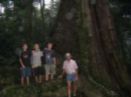
In the gloom of a primeval forest - Martin, Pete, Chayce and Norm in front of the Big Tree. |
After this, we had a quick stop at the Big Tree,
where we took some photos. After that, we
had a quick look at the Swynnerton Memorial,
before carrying on to see the Moodie
Memorial, which was quite overgrown.
However, it was very interesting to look
around, and to hear the story that Norm told
us about the first trek into the area.
After visiting the grave we headed off the main
office when Norm paid for us to go into
Chimanimani. After Norm had paid, we had
our lunch in the car park. We unpacked the
landy and took our backpacks and finally
started hiking to the base of the mountain. On
our way there, we had our first crossing of
ankle deep water. Surprisingly, the water was
quite warm. I fully expected it to be freezing
cold.
The terrain whilst walking up was quite rugged and tough going, but we all persevered. Our first
stop was at a place called picture point, but we didn't stay there long because we wanted to reach
Terry's cave before it was dark. In Chimanimani, it is pitch black at 6pm. We hiked through
banana grove and then started seeing quite a few awesome rock formations. There was a
certain rock formation that we had our pictures taken. On our way to Terry's Cave, we saw what
we thought were other hikers but were actually some gold panners. How we came to know that
they were gold panners was because on one of the descents we saw they had set up camp. We
carried on hiking to just above Southern Lakes. As it was too dark to hike down to Southern
Lakes, Norm found us a flat piece of land for us to set up our camp. Norm thought it might rain;
he set up a bivi, which we all slept under except for Christopher because he slept in his own oneman
tent. The reason why it was decided not to attempt to go down to Southern Lake was
because it was pitch black and Norm was worried that one of us might slip and hurt ourselves, as
the path going down was very steep. After we had set up camp, we unpacked out sleeping kits
and cooked our supper, had a hot drink and went to sleep.
After sleeping a rolling night, I woke up sleeping on top of Chayce and Peter. Martin was in
between Leon and Chayce, and Norm was next to Leon. Chris, who was sleeping in his warm
tent, was the last to wake up. After having breakfast we took down the bivi and walked down to
Southern Lakes. We had a swim, and Chris and Peter wanted to fish, but unfortunately there
wasn't enough time.
Click to enlarge: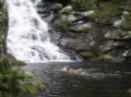
Swimming at one of the many falls in the Chim's - Bundi Falls |
After ten minutes we left
Southern Lakes and walked four and a half
kilometres to Terry's Cave and spent half an hour
there, while we had some more breakfast. After the
half hour was up we went on to another set of falls,
where we spent some time jumping into the water
from about 3 metres up. After that we went to a cave
known as Peterhouse Cave, and spent 10 minutes
there. We then continued to Bundi Falls, where
Peter, Chayce, Martin and I swam for 20 minutes or
so. While we were swimming, the others found a
snake in the water. When we got out we had some
lunch and Martin, Chris and I were the first to leave,
followed by Peter and Chayce and then Leon and
Norm.
We crossed a wide plain, known as the Bundi Plain,
heading to a waterfall called North Falls. When we arrived, we climbed above the waterfall to a
cave, known as North Cave, where we slept the night.
When I woke up it was so cold, all I did was have some breakfast. When Norm had woken up, he
asked around for volunteers to climb Peza, a mountain just behind the cave we slept in. I wasn't
sure if I wanted to or not, so I just volunteered, not really knowing what was in store for us. In the
end, it was only Norm, Leon, Dylan and I, so we left the others at the cave.
It was quite a climb up the mountain, but we finally got up and of course, had some chocolates.
We then phoned our parents quickly on Norm's cell phone, before the battery went dead. Peza is
right on the border of Mozambique and Zimbabwe, with
a concrete marker on the top showing the borderline.
Click to enlarge: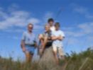
Passports? - Perched atop the border post at Peza - Norm, Pete, Leon and Dylan. |
When we were almost down again, I looked up and saw
something moving. When I looked again, I realized it
was an impala, the first animal we had seen in the
mountains. When we got down, we told the others about
our climb and got ready to move off. We packed and
filled our bottles with freezing water from the river, and
set off for the Mountain Hut, perched on a hill
overlooking the Bundi Plain. When we got there, we
stopped and had lunch for about an hour, and then
carried on down, following a path down known as
Bailey's Folly.
On the way down, some of us got a little confused with
the paths, and so ended up on the wrong side of a small valley and had to go back up a bit to get
to Norm, who was on the other side. By this time, he was almost down.
When we got down, I was so happy to have finished my first Chim's Hike. We all shook hands
and we each had a cold coke to
refresh us. We eventually left the
Parks Hut to go to Outward Bound
School, where we had some fun in
Tessa's Pool, jumping off the rocks.
We had a shower there, and then
Norm handed each of us our Hike
Shirts, which we put on and took a
photo.
Click to enlarge: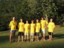
Clean, but for how long? The whole gang in their new Chim's T-Shirts. |
After this, we headed back into town
to the Chimanimani Hotel for dinner.
When we got there, Ken Nortje was
already there; he had come to join
us for our after-hike dinner. The
dinner was very nice, and we all
ordered hamburgers and chips;
though the power kept coming and
going. After dinner, we headed up
the hill to a lay-by, which took a long
time to reach. When we stopped, it was so cold, only Norm, Ken and Leon slept outside, the rest
of us stayed in the landy.
We stayed the night just outside of Chimanimani Village stuffed in Norm's land rover, except for
Norm, Ken and Leon, who could resist the cold. In the morning we had a bit of breakfast, said
goodbye and thank you to Ken for coming all the way from Mutare to meet us, and then left. The
next stop was to be Birchenough Bridge, where we stopped and walked across the bridge, with
the mighty Save flowing beneath us. On the other side, we climbed down beneath the bridge and
skimmed stones for a bit. Peter was really good
at this.
Click to enlarge: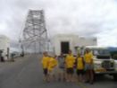
Clean, but for how long? The 1st descend on Birchenough Bridge. |
Then we carried on to the shops just after the
bridge, where we all bought a loaf of bread,
except for Chris and me, who thought ahead
and bought a tin of jam as well! Then we carried
on to Masvingo, where we found a petrol station
with a Wimpy, and we all had a coke and a
hamburger, which was nice. Then we carried on,
stopped in the middle of Masvingo somewhere
to buy some more cokes. After that, we just
drove straight back to Bulawayo, without any
more pit stops. We arrived home around 5, to
meet our parents and tell them about our long
expedition.
We all really enjoyed the Hike, and we can't wait till next year. Thank you Norm, it was an
unforgettable experience.
Chris Mackenzie
Chayce Zangel
Dylan Sandwith
Peter Daly
Martin Daly
The 1st's Post-Box:
This term, the 1st has received quite a few interesting letters and bulging parcels, so we thought we had better print them out here, in order to keep the supply coming.
Matthew's Winter Camp
Below is an e-mail sent to Norm by Matthew Swannack, who now lives in Canada, on the 5th of February 2006, telling of his winter camp.Dear Norm
I went on a winter camp last weekend. The first night we stayed in the chalet on Coldstream Ranch. It was very cold even though we made a fire. It was -5C in the chalet and I had a -6C sleeping bag but I was still freezing! The next morning we had eggs, pancakes and those funny potato thingamajigs (hash browns). Scouters Rick and Greg cooked breakfast and we cleaned the dishes afterwards with snow. We then packed up and went on the camp. We had to wear snowshoes, those things that look like tennis racquets, when we were finding a place to sleep. The snow was very deep and without snowshoes you will sink in the snow! One Scout had a broken snowshoe and he fell into the snow.
We found a nice place to camp on a ridge and we put all the big things on a sled and we carried our packs. We took turns in pulling the sled up the hill. My pack was very heavy because of all the equipment in it. I was the third one up the hill. We had to make the fire. It took a very, very long time because of the snow and water. We had to build a foundation of logs for the fire. This keeps the snow away. We needed frozen logs and they were put into the ground. We then started the fire and the logs will slowly burn. We were all doing something to build the camp while Scouters Rick and Sean made lunch. We had noodles.
After lunch we all started on the bivouac. Mackenzie and one other boy, can't remember his name, built the pooper. The pooper is a log on which they made a seat and you poop over the edge! The rest of us were building the bivouac. Scouters Brian, Rick and Greg helped. We had to chop down trees. We made a frame with a big log down the middle and little logs on the sides. We put the branches on the ground so that we did not sleep in the snow. We then put a tarpaulin over the branches and over the logs. It took five hours to build. We then went on a little night hike, as it was dark by now, around 4:30 pm. When we got back we sat around the campfire and talked and sang songs. For supper we had tacos. We then went to bed. We had a log under our mats and it was very uncomfortable!!!!
T he next morning Scouter Rick got up first and then I made the fire with the embers from the night before. Rick showed me how to sweep the snow off the embers and to start the fire again. It was -14C and I did not freeze to death because I used Scouter Rick as my personal pillow!! My boots were frozen when I got up and it was very hard to get them on my feet!! Then we had breakfast and packed up to go back to the chalet.
I got my knife, axe and saw permits. I had to cut down trees and I wasn't expecting to get anything yet! It was a nice surprise for me. I still need to get my match and fire, lamp and stove permits. I must carry these permits with me when I go camping.
I had lots of fun and I want to go on the next camp so that I can get my winter camp badge. John-C also wants to go.
Love Matthew
Tim's and David's Letters
We also received a letter from Tim Chadwick, along with a huge parcel with sweets and other goodies in it. Thank's Tim!Hi Norm and Troop
How are you keeping?
Well, it's been quite a "mild" winter so far, with a whole heap of thaws, so there is presently only 5-10cm of snow, and even patches of grass.
My dad has now resigned his job in Tanzania, and he's finding work here in Canada close to home, which will save on all the travelling!
Are you starting to get things ready for the 100 Years of Scouting Celebration at your end? Are you going to be the one organizing the whole thing? Well, there is going to be a huge camp here in Canada, somewhere in the Québec province, but it's going to be quite expensive attending. This summer our Troop will be going to the worlds 2nd largest Scout Park, which is here in Canada, and I believe the largest one is in the U.S., in the Nevada desert! This park has a huge lake situated in it, which has islands on it, used for camping grounds and survival training. There will be a canoe per two Scouts, and that is how one manoeuvres around this park. It will be a weeklong camp filled with activities. But we're going to have to do a bit of fund-raising before we go!!
I remembered how we loved getting parcels from Mark when he was in Germany, so we put together this collection of stuff for you. The CD's, which are in the parcel, did not work on these American computers, so I thought maybe someone in the Troop would like them.
Well, I'll keep in touch through e-mail, and I hope the condition in Zimbabwe improves. So long for now!
Love Tim.
David Chadwick also sent us a letter:
Hello Fellow Scouts!
Hi guys! For the few who don't know me, I'm David Chadwick, a Scout before I left, to those old guys who I know, I'm still the same as ever! I hope you guys are able to enjoy the green bush still! It's pretty cold here at the moment! We are also part of a Scout Troop, and I'm doing basketball and will be doing soccer, I'm also part of a Drama Club! Our Scout Leasers are very different here! You're lucky you have Norm! I've been able to switch my proficiency badges! Well, I send my regards to you all and I hope you can still go on all your Scouting Activities!
Remember! Be Prepared!
Enjoy!
From David Chadwick
Obey's Letter
A letter received on our return from our Chimanimani hike, from a family with whom we stayed a night on the way to Chim's. Their hospitality touched our hearts, and we thank them greatly.Dear Mr Scott.
I am very happy to write you this letter asking you the state of life; saying how are you? Here in Kondo we are very happy.
I wanted to ask you how your Journey was from Kondo to Mt Selinda and Chimanimani. I hope it was well and that it was a nice journey. Sir, most people here were proud of you and your boys and they are asking me when are they going to return here. Your visit was welcome to everybody in our Village and the Outskirts.
Proudly I wanted you to know that I am still thinking of you and your Scout Group; hands up to you, sir, for a day we shared together.
Please, Sir, if there arises an opportunity for work I would appreciate it, because everything is not good on my side. If an opportunity arises, please write to me on the above address. More Greetings to Chris, Leon, Martin, Peter and Chayce, and to the many others you work with. More Greetings from Siye-siye and Sheperd.
Yours Faithfully,
Obey Cames Makuyana.
An ex-Scout of the 1st, John-C Swannack, who left us last year to go to Canada, wrote the
thought for this magazine.
Can you hear..?
Can you hear the shooting star shooting across the sky?
Can you hear the sun rise slowly behind the mountains?
Can you hear the Earth turn beneath our feet?
Can you hear the black clouds building in the sky?
Can you hear the sun's rays beating on your face?
Can you hear the snow fall and land on the roof?
Can you hear the fish's thoughts as it swims around its fish tank?
Can parents hear their children grow taller and bigger each year?
Can you hear our Earth as it evolves each century, as life goes on?
No, these are the sounds of silence.
1st Bulawayo (Pioneer) Scout Troop
Troop Programme of Activities for May to August 2006
May
5 - 7 Rotary Weekend: Gordon Park
12 Troop meeting: Mabukuwene
14 Gordon Park Service: 12.00 noon
19 Troop Meeting: Mabukuwene
25 Africa Day
26 - 28 Colin Turner Memorial Pioneering Competition: Gordon Park
June
2 - 3 Monthly Hike
9 Troop Meeting: Mabukuwene
11 Gordon Park Service: 12.00 noon
18 Troop meeting: Mabukuwene
23 Troop meeting: Mabukuwene
30 Troop Meeting: Mabukuwene
July
7 - 8 Monthly Hike
9 Gordon Park Service: 12:00 noon
14 Troop meeting: Mabukuwene
15 - 16 Parent's Camp: Gordon Park
21 Troop Meeting: Mabukuwene (Sausage Sizzle)
28 - 30 William Arnold Carnegie Assegai Competition: Gordon Park
August
1 - 31 Provincial Scout Commissioner's Hike
4 - 5 Monthly Hike
11 Troop meeting: Mabukuwene
13 Gordon Park Service: 12.00 noon
18 Troop meeting: Mabukuwene
25 Troop meeting: Mabukuwene
Additional Activities may be added to the Programme